Before It's Gone Journey
  • home
    • About Us
    • Contact Us
  • Blogs
    • Himalayan Livin'
    • The B.I.G. Cycle Journey
  • Get Involved!
  • Advice and Reviews
    • Apps

Hiking Helambu and Gorgeous Gosainkunda

10/27/2014

1 Comment

 
Picture
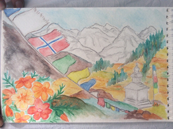
Casey created this in honor of her Grandpa Ivan who was very proud of his Norwegian heritage!
Trekking Days 1-9 
Highest elevation: 15,120 ft (4,610 m) 
Lowest elevation: 4,790 ft (1,460 m)


The taxi dropped us off in the late morning at the trailhead in Sundarjial, a community on the outskirts of Kathmandu. In keeping with typical Casey and Matt tradition, our lightweight packs were stuffed to the brim and it was barely manageable to pick them up and put them on our backs. We had been up late the night before, configuring and reconfiguring all the pieces in order to force everything to fit. Among the weight and space culprits was a 16-foot long Hilleberg tent, perfect for cycle-touring but perhaps not so logical for this endeavor. We also got a little over-ambitious at the supermarket, and stubbornly refused to leave any of our goodies behind, thus cramming Snickers and granola bars into any unfilled niche of carrying capacity. 

Our first day was spent crossing Shivapuri National Park, and by crossing I really mean ascending continual stairs through small villages and lushly foliated forest. We gained 700 meters (2,300 feet) and were rewarded with our first clear panorama of peaks at sunset just as we reached our stopping point of Chisapani. We randomly chose one of several lodges in the town, a multistory concrete building painted bubble gum pink with electricity, wifi, private bathrooms, and hot showers. (The hot shower was a bit ironic since chisopani means "cold water" in Nepali.) This "teahouse" was no different than a cheap hotel in Kathmandu and certainly not what we were expecting. Then again, we were not yet that far from the city either.

Despite committing to a thorough stretching routine the night before, the next morning my lower back was so tight that I headed down the trail hunched over like a very old woman. It took a good hour or so before I could hike all the way upright. Additionally, I self-diagnosed a tight IT band causing some significant pain in my left knee, likely irritated by the oversized steps we climbed for hours the day before. The only relief was to avoid bending my left leg by taking the steep downs with my left foot always leading and my right matching it one step at a time and leaning on the trekking pole I promptly borrowed from Matt's pair. This obviously made for slow going, but our cardiovascular system would not have allowed much of a faster pace anyway.

By the end of our second day, we were exhausted and every muscle from head to toe was sore. We had also both developed raw patches of skin on our lower backs from a bad combination of sweaty clothes and rough fabric on our as-of-yet-un-field-tested packs. It was clear that our bodies were in shock from the sudden onset of physical demands upon it. This was not terribly surprising since, with the exception of a few days of cycling in Nepal, we had not been significantly active for over a month! We had spent eight days off the bicycle in China, prior to a ten-day tour in Tibet, followed by almost two weeks of hanging out in Kathmandu. A solo American man, also with a large pack, passed us as we were resting on the side of the trail and astutely commented, "It hurts the worst for the first five days or so, then it isn't so bad...The Germans will give you a hard time about your big pack. I guess it's an American characteristic that we can't part with our things."

Well, at least it didn't take a full five days to physically settle in to our two-month trek. Our second day was a long push through forest and fog to a nice establishment called the Thodong Lama Hotel, complete with a wind-powered prayer wheel and Buddhist motifs of the eight auspicious signs on the walls. The third day was a short one; after just a couple of hours hiking in questionable weather and feeling quite low-energy, we stopped at a lodge that offered us a room with an amazing mountain view. 

That half of a rest day proved to be our turning point. Starting out on sunny day four, our packs somehow felt miraculously lighter, even as we were hiking uphill for a total of 4,000 feet. Once we were physically recovered, we had the mental energy to transition from a perspective of simply surviving the trek to loving the challenge of it. The worst of our ailments were behind us, except each of our pinky toes had transformed into one continuous blister covering all sides. It would take a full two weeks before they were replaced with thimble-like protective callouses instead. 

When we finally made it above tree line, we were rewarded with an amazing sunset from a crowded teahouse perched on a ridge line, while the temperature also plummeted. On day five we were not so lucky. After a tough day of "Nepali flat," meaning continually hiking straight up or straight down yet staying at the same average elevation, we stopped at the uniquely named Dawababy Redpanda Hotel. The clouds never lifted to reveal the mountain view, so the friendly owners with no less than nine children watching our every move became the entertainment of the evening.

First they piled in to one end of the wood stove warmed dining room to observe all the guests eating their dinners, then the tourists sat around while the family ate Nepal's national dish of dal bhat, which at a minimum includes a mound of rice, lentil soup, and seasonal vegetable curry that seems to always includes potatoes. It may also come with a papad, a crispy peppery very thin bread, and the whole dish is traditionally eaten with the right hand. The best part about dal bhat is that second and third helpings are freely offered, unlike other menu items, so it is a super healthy way to get filled up at the end of a calorie intensive day. The few nights we ordered other things like pasta or soup, we spent more money and went to bed still hungry. Each lodge prepares the veggie curry and lentil soup a bit differently, so having it every night is not unbearably repetitive. If we were Nepali, we would eat it for lunch and dinner daily.

From the Dawababy in Phedi, we made an exception to our no alarm clock rule and got an earlier start for our first major pass. We were still the last trekkers to leave to the lodge at 7:45am, but almost two hours earlier than we had been. Heading up, we were being chased by clouds rolling up the valley. We feared they would beat us to the top, but we could not go any faster. We made it in time to enjoy clear views and relaxed with our lunch of veggie momos near a cairn draped in prayer flags marking the summit. Nearing the top of the 15,000 foot Larabina pass, we began hiking on a packed snow trail, which continued down the much snowier other side. We were early enough in the day that we did not punch through the snow, but late enough that the treacherous slick crust had softened enough to allow some grip. We passed by several of the 108 holy lakes in the Gosainkunda area, 108 being an auspicious number in Buddhism and Hinduism. The snow-covered landscape made the blues of the lakes even more dramatic.

We reached the lakeshore of the main lake, where thousands of pilgrims converge each summer to bathe and complete a kora around it. Shiva, one of three main Hindu deities, once stirred the ocean in search of Amrit, the water of eternal life, but instead churned up a threatening poison. He then drank it in an act of protection, thus spurring him to strike his trident into the earth at Gosainkinda where pure cold water spilled forth and cleansed him of the ill effects of the poison. 

We were quite taken with the beauty of the place and charmed by the friendly young couple managing the Lakeview Lodge. Being the coldest place on our trek thus far at around 14,000 feet, everyone cozied up in the dining room for the evening, only venturing out for photos of pink peaks over the lake at sunset. We decided to stay an extra day, heading up the hill behind the lodge for a viewpoint of the mountain ranges on the other side. We made the ridge line just before clouds rose up the valley, entirely obscuring the vista. Back down at the lake, we completed the kora just as the wind picked up and tiny spits of hail stung our faces. By the time lunch had warmed us up inside the lodge, the weather had done a 180 from the sunny morning, including some startling claps of thunder. We kept tabs on the status of the snowstorm from our window perch by the fireplace while reading the afternoon away.

The next morning had clear skies again, but with a small accumulation of snow and frozen water lines from the spring across the hillside. We bundled up, but with our standard leisurely departure, it was pretty warm by the time we left and we promptly peeled layers off. We descended from a winter wonderland into a stunted high-altitude forest being pelted by hail, and continued down to a dense moss-covered forest where the canopy sheltered us from rain. The village of Sing Gompa at 10,000 feet felt a world away from where we started that morning, not only because of the comparatively warm and lush environment, but also due to the presence of freshly baked cinnamon rolls, a nak (female yak) cheese production center, and a private bathroom with a western toilet and a solar shower (sadly quite cold due to the cloudy weather) at the Yak and Nak Hotel!

Leaving Sing Gompa, we took the wrong trail out of town, albeit with some suspicion at the rapid descent. Just as we were about turn around and face the big climb back, Matt pointed out a large bird sitting in a pine tree. I looked over and said, "Yeah, it looks like a monkey...Wait! It is a monkey!" Our wrong turn resulted in our first langur monkey sighting of the trek. They had beautiful light grey coats with round black faces and some of the longest tails I have ever seen, even for monkeys. These are the things that inevitably happen when you don't have a guide. 

In contrast, once we finally got going on the right trail, we met a tremendous group of French trekkers that, combined with all of their porters and guides, seemed to take up the length of the trail they were covering that day. We were grateful that we were going in opposite directions. 

By early afternoon, we had reached Thulo Syabru, a popular stop among trekkers for its internet access. Here I found out that my ninety-year old Grandpa Ivan had passed away just a few hours earlier. Had we not taken the wrong trail that morning, I would have checked email before my dad sent the news of my grandfather's passing, and we would have kept going down the trail. Instead, we stopped for the day and I was able to talk with my parents and my grandma, took some time to reflect and honor the life of my grandpa, and found comfort in a pot of real organic coffee at one of more than twenty-five hotels sprawled along a steep ridge line. While I will of course miss my grandpa dearly, he died in peace surrounded by all of his children after a return of cancer and entering hospice, so the event was not unexpected. After connecting with the larger world for a little while, we were ready to transition to our next section of the trek: Langtang Valley. 
1 Comment

Kickin' it in Kathmandu

10/18/2014

1 Comment

 
From Bhaktapur, it was a short ride in to Kathmandu, where we beelined it for Thamel, aka tourist central. Our aim was to quickly figure out a trekking plan, get preparations underway, and hit the trail before we lost any more time during the best weather season. Once again, our best laid plan was soon turned on its head, but this time in the best way possible. 

We set out to familiarize ourselves with the maze of narrow, canyon-like streets of Thamel since we were at a loss as to where to begin our trek organizing process. Soon we poked our heads into Beni Handicraft, a store selling handicrafts made from repurposed trash, and met David Durkan, an energetic ex-pat staffing the shop who struck up conversation with us. We explained that we were anxious to get trekking, but had not yet researched options or decided on a route. That was all we needed to say for him to adopt us for the afternoon, sharing a wealth of knowledge accumulated from thirty years of experience in Nepal as well as snippets of his fascinating life, which he details in his locally published book Penguins on Everest, donating all profits to the NGO Autism Care Nepal.

Now feeling overwhelmed with options, we headed to a book and map store to select some printed material for more detailed research. While comparing two maps of Nepal selected from an extensive collection, a voice over Matt's shoulder said, "Don't get that one, take the other." He turned around and asked the British man why, who then responded with a grin, "Because I made it." This of course paved the way for an insightful conversation with Robin Boustead, a cartographer who has hiked, mapped, described, photographed, written books about, and otherwise promoted Nepal's Great Himalaya Trail. 

The GHT is billed as the highest long distance trail in the world, running about 1,700 kilometers (1,000 miles) along the High Route in Nepal alone, but stretches from Bhutan to northwestern India in its entirety. While he waited to meet with the manager of the bookstore regarding the release date of an updated GHT map, Robin's enthusiasm inspired us to start dreaming of attempting the formidable trek ourselves. After all, we had no future commitments in our open ended journey. The limiting factors would be the arrival of winter, expense, and as we would soon learn with further investigation, a lack of technical mountaineering experience as well. Our first day in Kathmandu turned out to be an impactful one; just by wandering around we met two local experts who broadened our trekking ambitions from only the overrun Annapurna Circuit and the ever-popular Everest Base Camp. However, the full significance of our serendipitous meetings would not be realized for another week or so. 

We celebrated our epic day with delicious wood-fired pizza for dinner, the first good pizza we had eaten since curiously checking out a Pizza Hut in Beijing. Of course, this was much better!

Besides taking care of travel errands such as laundry, the next day was dedicated to furthering our now difficult trekking decision. We spent the afternoon at the office of Kathmandu Environmental Education Project, a local NGO who provides unbiased trekking information through firsthand trekker accounts in logbooks, access to maps, a library, and most importantly, information on how to trek responsibly. By then, we had honed in on the idea of trekking the eastern sections of the GHT this season and saving the rest for future trekking seasons. Now we needed to find an agency to arrange the logistics of permits and a guide. We stopped in at one place listed on the GHT website as specializing in treks to the Kanchenjunga region, which would be our starting point. However, upon meeting with the agent, it became obvious that the specialized knowledge we were seeking was not there. We moved on to David Durkan's recommended company, Asian Heritage, and the owner Nilam was both personable and straight forward with answers to our questions. He said he would get back to us in a couple of days regarding the details of government issued permits and the availability of an experienced guide for that region.

With our trekking process on hold, we turned our attention towards seeing more of Kathmandu. We spent a day taking in the many sights of city life between Thamel and Durbar Square, from finding the best lassi we have ever had to watching Hindu women fondling strands of shiny beads at a dedicated bead market. By the time we actually got in to Durbar Square, the center of religious and political power of the former Malla royal dynasty, we had hit sensory overload.

We also caught up with a cycle tourer we had met at our hostel in Xining, China. William had also taken the train to Lhasa and toured with Explore Tibet to the Nepal border before cycling to Kathmandu, arriving just a few days after us. Like us, he was also in the process of figuring out his next moves for his long-term travel. Unlike us, he seemed content with the prospect of chilling in Kathmandu for a while, whereas we were already getting antsy to get out. 

Our readiness to move on made our next meeting with Nilam all the more disheartening. He had consulted with a guide that had done the section of GHT that we had set our sights on. Not only was the guide already booked up for the rest of the season, but he emphasized the need for a handful of porters to get through a week of jungle without any options of a provision resupply, followed by three challenging passes over 6,000 meters (19,600 feet) high. We were not yet ready to commit to the level of logistics and expenditure required, nor did we feel we had enough experience to safely take on the technical high-altitude passes. Six days spent in Kathmandu and we were back to the drawing board.

As though it was intended to match our mood, it began down-pouring and did not stop for two days. The streets transformed into rivers and pools of the dirtiest brown water imaginable. Shopkeepers pulled their wares away from the storefronts that usually spilled into the streets. We still didn't know which trek we were doing, but we felt an urgent need to accomplish something tangible, so we decided to go shopping.  We walked loops around Thamel, comparing practically identical products and prices. We were soaked to the bone before we committed to any specific fake North Face down jacket or knock-off Leki trekking poles.

We had a vague awareness that this heavy rain was unusual for this time of the year, the result of a monsoon storm that had hit India and kept going. Then, the next morning after the sky cleared, the sobering news came in the storm had translated to freakishly intense snowfall and blasting winds that settled on the highest pass of the Annapurna Circuit, killing an undetermined number of tourists and Nepali guides and porters. Some were caught in avalanches and others lost their way and presumably died of hypothermia. We tracked the news stories over the coming days, including helicopter rescue for those who were fortunate to have hunkered down in lodges to wait out the storm. With six feet of snowfall in 12 hours reported and the death toll confirmed at a minimum of 43 (but likely quite a bit higher since many bodies have yet to be recovered as I write this), the incident is regarded as the worst trekking disaster in Nepal's history. We gratefully reflected that, had we not met David and Robin, resulting in a longer trekking research process, we may have been on our way around Annapurna ourselves. One option we had been considering was cycling the Annapurna Circuit on the dirt roads that have been controversially constructed along the route in the last few years. 

It was Matt's idea, likely the product of his habit of pouring over maps, but I latched on to it quickly and wholeheartedly. Why not trek from Kathmandu to Pokhara and take care of roughly the middle third of the GHT in the process? We brought our new plan to Nilam and he approved too. We would be able to hike the first month on our own, then if we were still game to keep going, he would send a compulsory guide to meet us with permits for the sections that are deemed "restricted areas" by the government. All we had to do was leave our passports and our credit card with him! We figured this was either a really great guy who was prioritizing our flexibility over his business gain, or we would soon be financing his luxury vacation to Somewhere Far Far Away...We decided to bet on the former.

That was actually the least of our concerns as the concreteness of a plan suddenly quadrupled the length of our to do list. It seemed like endless details needed to be taken care of over the next few days, everything from getting our trekking permits at a government office and meeting with our future guide, to stocking up on chocolate bars and buying a cheap emergency cell phone. One of the most pressing logistics was finding storage for our bicycles and extra gear. Luckily, a friend of a friend was willing to keep them in their storage room at their family home not far from where we were staying. 

When we had met David and Robin on our first day in Kathmandu, it was both of their last days in the city before leaving for projects elsewhere in Nepal. We were still there when they returned from their work, and both kindly offered to meet with us again to discuss our specific trekking plan. When David learned that we were passing through Tipling, he called his friend Beni to come meet with us as well. She is from Tipling and is the founder of Beni Handicraft, the store selling upcycled goods made by imprisoned women where we first met David. She encouraged us to visit her parents when we arrived in her hometown.

Later that same evening, we joined Robin and friends at his favorite watering hole, Sam's Bar. While spreading out a map across the tiny bar table, he gave us the skinny on the Ganesh Himal Ruby Valley trek, the one region we still felt a little unsure about. Conveniently, he had just returned from conducting trail research there (while coping with snowfall from the same storm that hit Annapurna so hard) so his information could not have been more up to date. He even gifted us one of his last copies of the first edition of his Great Himalaya Trail guidebook!

Our last obligation was to return to Nilam his signed copy of The Great Himalaya Trail written by Gerda Paula, a German woman who through-hiked the GHT in 2012 as a charity walk for Autism Care Nepal, and friends with David Durkan as well. She wrote an account of each day on the trail. I read the relevant sections out loud to Matt, over our "goodbye to civilization" dinner at The Roadhouse Cafe, the same wood-fired pizza place where we also ate our first night in Kathmandu. Next stop was the Northfield Cafe, where we gleaned the last tidbits of information about the route ahead of us accompanied by a brownie sundae and our last organic coffee for the foreseeable future that then kept us up all night...oops. Our last day perfectly mirrored our first day; we met the same people, ate in the same places, and, after our spell of disenchantment with the process, we were once again filled with the same sense of anticipation and excitement.

The White Lotus Guesthouse owner was somewhere between shocked and congratulatory when we actually checked out the next morning, after several days of telling him "just one more day." We were more than ready to leave Kathmandu after getting stuck there for about two weeks, much longer than we anticipated. We only hoped that the thoughtful research and thorough preparation for our trek would pay off once we hit the trail.
1 Comment

From the Border to Bhaktapur

10/7/2014

0 Comments

 
After getting a 90-day visa on the Nepali side of the border crossing without hassle, we continued to push our bikes through the one-street town of Kodari in a daze. We were absorbing the fact that we were suddenly a whole lot closer to India than China just by crossing from one side of the river to the other. It was crazy to think that the people still visible on the other riverbank operate in the same environment under an entirely different set of cultural rules and political systems. Borders are strange things.

We were also pushing our bikes because we couldn't quite muster the energy to get on them and start riding toward Kathmandu. Even though we had been mostly sedentary on our Tibet tour, we were exhausted from the long days, on a schedule that was not our own, and negotiating logistics with our guide. In addition, seemingly exactly on cue with the border crossing, we were both struck with mild cases of digestive issues. All of this signaled we needed a rest day before taking on the exploration of a new country. 

We settled in to a niceish guesthouse that was amenable to taking US dollars. Upon crossing the border we learned that banks were closed for Nepal's fifteen-day long Dashain festival, a Hindu celebration of the triumph of good over evil. The only ATM in town was broken and the obligatory sketchy money changers usually found at border crossings were mysteriously absent. The subsequent requests to pay with dollars at shops and restaurants were met with a confusing side-to-side head bobble along with a smile. It didn't look like a no and it didn't look like a yes. Referencing our guidebook confirmed our inference from context; it is trademark Nepali body language for being in agreement with someone or something.

The next day we felt much more energetic and prepared to ride. It turned out to be a good thing that we stayed in Kodari since the Araniko Highway that the Chinese financed to Kathmandu back in the sixties had seemingly received no maintenance since then. We had to crank down on our brakes to slow our steep downhill momentum because the road was so potholed and bumpy that our bags would otherwise fly off our our bikes.

While we had been anticipating a nice easy descent to Kathmandu for some unfounded reason, we were actually navigating the much more logical rollercoaster of climbing and descending as we crossed ravines of the tributary streams along the side of the dramatic main Sun Koshi river valley. We took an unexpected break along an uphill stretch for the nice surprise of watching a troop of monkeys cross the road, the most exciting wildlife sighting of our entire journey to date!

Later in the afternoon, we reached the highly anticipated landslide that had been the talk of all the tourists traveling from Tibet to Kathmandu. The massive landslide had actually occurred in early August during a period of heavy monsoon rain, even making international news. A section of slope 1.9 kilometers (1.2 miles) long slid into the river, creating a dam that formed a lake extending 3 kilometers (1.8 miles) upstream. Two dozen houses were buried and at least 156 were killed. Until August 27, when a track began on August 16 by five bulldozers was completed, air travel was the only means of reaching Kathmandu from Tibet. A group of businessman dependent on the route for the import of Chinese goods financed the project. Nowadays, with still no sign of real road repair, most travelers catch a bus to the landslide, walk a rough trail along the foot of the debris at river's edge for an hour, then catch another bus on the other side. Higher budget or more time-conscious travelers hire a jeep to take them across the landslide.

When we reached the edge of the landslide, we dismounted and got no further than five feet down the pedestrian path along the river before a group of women insisted it was not possible for us to go this way with our bicycles. As far as we could see, it seemed feasible, but we skeptically turned around and started to push our bikes up the rutted truck track into the heart of the landslide. At this point we thought it would be a short incline, but at the top of the first rise, the countless switchbacks revealed themselves and the scale of the slide became fully apparent for the first time. We could barely keep our bikes going forward while digging our feet in to the soft ground. 

To make matters even more challenging, we were leapfrogging with trucks that were lurching along in short spurts between episodes of getting seriously stuck. We would have to drag our bikes out of the tire ruts to let them pass, then negotiate around them on the crumbly edge of the road when they were stuck. It seemed like forever before we reached the top and going down the other side was almost fun. Matt rode down the switchbacks, periodically getting thrown off when the bike wobbled in a sinkhole. I opted to run with my bike, kicking up clouds of dust that shimmered with tiny flakes of mica in the fading sun. 

Between the extra hard workout and being unaccustomed to the humid heat after cold, dry Tibet, we were ready to call it a day in the next village we came to. We stayed in a simple place that was not so clean, and had a selection of very basic restaurants that also looked not so clean to chose from. However, everyone was very friendly and patient with our lack of Nepali money, language, and knowledge of their country and customs. We were shocked that even in a small village that was completely the opposite of being affluent, most people had enough English to make interactions a piece of cake compared to a similar evening in China. Despite this we felt a bit hesitant and shy, as though we had just started traveling for the first time. It made us realize how much we had developed a comfort zone in China, and now all of the factors that had created our sense of routine had been shaken up.

The next day we climbed through the hills that create one side of Kathmandu Valley on a narrow road that was particularly busy with family visiting family for the Dashain holiday. One thing felt all too familiar: black clouds of exhaust from tailpipes pointed at our faces as overloaded busses, jeeps, and trucks passed us, while they were simultaneously getting passed by gangs of motorbikes. Our bodies were feeling the effects of nearly three weeks off the bicycle prior to our arrival in Nepal as well. We stopped a little before sunset near the ridgetop town of Duhlikel, with panoramic views of Himalayan peaks when it is clear, which it was not for us. 

The bizarre resort hotel that we quickly chose before dark specialized in over-promising and under-delivering, especially for the pricey price. The hot shower was not hot, the toilet handle would not flush, the door wouldn't lock, the wifi would not connect, and the solar back-up light in our room was out, which had been installed for Nepal's regularly scheduled load-shedding electricity cuts. We tried our best to resolve what we could with the hard-working manager, feeling that the problems were due to the absentee owner's neglect more than a direct reflection of Nepal being in the world's 16th poorest country, as indicated by average national income. In the United Nations Human Development, Nepal ranks 157 out of 187 countries (as of 2012).

The next morning we got a partial peak at the famous mountain view before heading down into Kathmandu Valley. We stopped about ten miles short of Kathmandu in the historically significant and well-preserved city of Bhaktapur. Nicknamed the City of Devotees for the diverse collection of Hindu temples--a few Buddhist ones too--as well as small shrines tucked down alleyways and on nearly every corner. In the 14th-16th centuries, Bhaktapur was the most powerful of three rival kingdoms in the Kathmandu Valley. To prove this, the Malla kings constructed no less than 172 temples in a show of competition with Patan and Kathmandu itself. Even today, Bhaktapur remains the best preserved of the three.

The only thing superseding our excitement about the opportunity to explore this intriguing place was the discovery of a working ATM, followed by the fact that Nepal grows its own organic coffee! We wasted no time in sampling this treat, which we had not enjoyed for quite some time, and determined that it was excellent. Just when China had fully weaned me of my coffee habit and forced me to appreciate the qualities of tea...

With a decent caffeine buzz going, we settled into the Kumari Guesthouse on a corner of Durbar Square just before an intense afternoon rain and hailstorm. We spent the rest of the day and the next taking in the sights, from pottery-making to festival processions to plain old people-watching. We were starting to get synced with the rhythm of Nepal, one that we could tell would keep us grooving for a long time.
0 Comments

Ten Days in Tibet (Part Two)

10/3/2014

2 Comments

 
We left the next morning with a new driver and a new guide, who had not been informed that we would be wrangling two bicycles into the back of the minivan. The explanation for having a new driver was that is was "the busy season," whereas our first guide had to report in person to the police for a previous driving citation or risk losing his license. Our new guide, Nawang, looked like he was about fourteen, but claimed to be nineteen. Regardless, his texting habits and general cell phone attachment were on par with his American peers.

Our drive roughly southward brought us to viewpoints of Yamdrok Lake, another holy lake that is shaped like a scorpion from a Google Earth perspective. After traveling along its shores, we stopped for lunch and tried the infamous yak butter tea. We were pleasantly surprised at how drinkable the slightly thickened concoction of black tea, salt, and of course yak butter was. It reminded me a little of plain yogurt mixed with salty soup broth, and it was easy to understand how this is comforting sustenance to Tibetans in such a harsh environment. 

In the afternoon we visited an unique religious structure called a stupa in the city of Gyantse. Imagine a giant white tiered wedding cake, where pilgrims and tourists can walk around each layer, pausing to peer in to small dark rooms holding shrines to deities. This Kumbum stupa is the largest remaining in Tibet with an imposing fortress perched on a nearby hilltop and guard walls snaking along the length of the ridge line. 

Onwards to Shigatse in the evening light, we stayed at an ornately decorated palace-like hotel where confusion surrounding our request for a queen room once again resulted in a nice upgrade. We didn't have much time to enjoy it though as we had arrived late and still had to seek out dinner, successfully keeping with the Tibetan theme. Patronizing only Tibetan-owned restaurants while in Tibet helps their survival in the face of increasing competition from Chinese-owned businesses, as well as raising the percentage of locally produced food in our meals. Besides, we had definitely had enough Chinese food for a while.

Already our seventh day in Tibet, we barely managed to eek out a breakfast at the buffet overrun with Chinese tourists beginning their extended national holiday break. One man piled his plate high with rolls, leaving just one behind. He turned to Matt, pointed at the lone roll, and said "Enough," clearly intended to imply that he was not being greedy because he left one for us to share. Incredible...

Despite the hungry start to our day, we enjoyed walking around yet another monastery. While many elements are the same, the specific history, context, and atmosphere of each one keeps it interesting while experiencing its unique "personality." Our guide was busy getting yet another government permit for us, this one with the lovely name of "Alien Travel Permit," so we were left to simply observe and take in the Tashi Lhumpo monastery on our own. 

Without a guide to focus on, our attention gravitated to the devoted worshippers who dutifully poured more yak butter into already overflowing vats with rows of lit wicks embedded in to them. A monk would dutifully scoop out the excess yak butter into a plastic container, leaving a cavity for the next worshipper to fill. Prostrations and offerings of bills in minuscule denominations, ironically all with Chairman Mao's portrait on them, were also made in front of key statues. It appears that the main occupation of the monks present in the chapels was counting money, secondary only to controlling yak butter levels in the lamps. Most pilgrims whipped through each room at a breakneck pace with so many deities to visit, but their speed conveyed a sense of purpose rather than ambivalence or disregard. More than anything else that we witnessed, these acts of pure and genuine devotion gave me hope for the survival of Tibet in some form, whose religion is inseparable from every other aspect of its culture.

The Tashi Lhumpo monastery was the historical residence of the Panchen Lama, the second most important spiritual figure after the Dalai Lama. Since the invasion, the Chinese government has installed their choice of Panchen Lama successors, of course disregarding the traditional process where the Dalai Lama conducts a thorough search for the reincarnation of the previous Panchen Lama. When the tenth Panchen Lama died under suspect circumstances, having been Chinese-groomed but evolving into a vocal advocate for Tibet, the Dalai Lama identified a six-year old boy as the correct successor. The Chinese government instead bestowed on him the honor of becoming the world's youngest political prisoner and forced the hand of Tashi Lhumpo's lamas to promote the Chinese-approved son of Communist Party members as the next Panchen Lama. The Dalai Lama-appointed boy and his family have not been seen since...so...will the real Panchen Lama please stand up!?!

After some drive time and lunch break, we visited--you guessed it--another monastery! This one was memorable for its immense library; the high-ceilinged corridor felt like it was lifted straight out of Hogwarts. This feeling was enhanced by the fact that the sacred texts do not look anything like a regular book. They are long rectangular bricks of pages sandwiched between a thick wood cover and wrapped in brightly colored cloth. 

Regional clouds rolled in as we finished our visit at Sakya monastery, thus obscuring what would otherwise be our first views of the Himalaya and Mt. Everest as we crossed over a 5400 meter (17,700 feet) pass and headed to the highway strip of Shegar to overnight before heading toward Everest Base Camp early the next morning.

Leaving with the first morning light did not equate with an early arrival at EBC, as the majority of the 100 kilometers (62 miles) were along a rough bumpy road in a vehicle less than ideal for the trip. We were informed that the four wheel drive vehicles had all been rented by Chinese tourists at highly inflated prices, so travel agencies put foreign tourists in all the leftover vehicles, since they are generally unwilling to pay any more for their already expensive tour. 

The vehicle turned out to be the least important thing we were competing with the Chinese tourists for. When we finally arrived at Tent Camp, a collection of 40 or so black tents set up in an inward-facing rectangle on a barren rocky field, we discovered that the alleged reservation we had for beds in a tent was supposedly outbid by Chinese tourists. Our guide and driver seemed at a loss for what to do, but eventually began timidly poking their heads into a few other tents, coming back to report that all of them were full. Here we forcefully suggested to our guide that if the Chinese were "stealing" reservations, then he simply needed to pay more than what they offered to re-secure our reservation. After some more time wandering around, we don't know how he did it since communication was not his strong point, we ended up in a tent with a beautiful and friendly hostess. 

After a quick but less than filling lunch of instant ramen, we walked the remaining four kilometers up to the official Everest Base Camp. When we arrived, the all-important peak was hidden by clouds. We decided to wait for an opening from the viewpoint bedecked with mounds of prayer flags, perhaps due more to a few persistent prayer flag salesmen pestering the tourists than actually being a location of great spiritual value to Tibetans. Combatting the biting wind with only a light jacket and scarf wrapped around his head like a ninja, our guide quickly got too cold and opted for a bus ride back to tent camp while we huddled in a windbreak. Our patience paid off and the panorama of white colossal mountains soon cleared of clouds for longer than our dropping body temperatures allowed us to remain stationary. We warmed up quickly though on our brisk walk back down to tent camp, peering back often at Qomolangma, the Tibetan name for the highest mountain on Earth, meaning "Goddess Mother of the Universe."

The tent was cozy from the wood burning stove, as well as six Czech cyclists who we talked with enviously. The twenty days it would take to cycle the same route we were doing in a week was simply out of range for our travel budget. Since the guide and driver would still be required to follow slowly in a vehicle behind us, our environmental impact would have been greater as well. We could have at least cycled from tent camp up to the viewpoint, but we did not want to deal with the hassle of getting the bicycles out of the van. Ironically, when we returned on foot, our driver made us unload everything so he could rescue a fellow driver and passengers from a vehicle breakdown along the rough road. Wedging the eight panniers into every nook and cranny of the tent certainly added to its coziness as well. 

Our two beds were really one long narrow ledge, which really didn't work with our one Big Agnes double sleeping bag. Meanwhile a perfect double bed sat empty, reserved for some Chinese tourists who never showed up. Perhaps from altitude, but more likely from the uncomfortable bed situation, we were awake in the middle of the night to witness the bizarre police patrol that silently entered the tent, shined bright flashlights on all the sleeping folks as well as us, then left. Apparently, they visit each tent every night to ensure that no one is over their quota of guests in order to keep the profits equitable among all tents. It seemed unnecessary this particular night as every bed in tent camp was full. This is the work that occupies police at the highest police station in the world, and by police station I do mean police tent. On the other hand, the highest post office (tent) in the world was a happening place, with nonstop postcard selling and stamping, thus sending hand-scribbled musings of the novelty of it all 'round the world.

The next morning dawned cold and clear, with a dusting of snow covering the ground as well as our bicycles locked up just outside of our tent. Throngs of people wandered out across the open expanse beyond tent camp to photograph Everest in the early golden light. Even more throngs of people were lined up to take the shuttle bus up to base camp; you could feel the tension in the air as people calculated how many bus loads were ahead of them and would they miss the morning light? Would they beat the clouds? We were relieved that we had visited the afternoon before at our leisurely pace of walking both ways.

Surprisingly, our driver returned from his overnight rescue mission right on time. We reloaded the van with our bicycles and gear and mentally prepared for another long day of sitting in the vehicle. Except for a brief visit to Rongbuk Monastery, the highest in the world (of course), the only other sightseeing stops were for roadside photos and more roadside time-killing before reaching the speed checkpoints. Amazingly, in one day we descended from EBC at approximately 5,200 meters (17,000 feet) to lush, humid forest with waterfalls cascading down every slope at the Tibet-Nepal border, hovering around 2,700 meters (8,850 feet). We literally drove to the edge of the Tibetan Plateau and nose-dived down the steep side of it until we reached Zhangmu, a border town that looks and feels a whole lot more like China than Tibet.

That evening we shared a really nice dinner with our guide and driver, as well as a few beers. Ironically, this farewell evening held the best conversation of the whole trip as they seemed to suddenly open up as well as take a personal interest in us for the first time. I am sure the beers had something to do with it. The conversation did hit a standstill when I asked what they think foreigners can do to help Tibet. Some words were exchanged between them, but nothing got translated back to us. It was a question we had been pondering on our tour, and one with no easy answers of course. While the thought of Tibet regaining its political sovereignty seems far-fetched after so many decades of occupation, there is still a cultural and spiritual Tibet worth fighting for the preservation of. "Free Tibet!" is not yet an irrelevant slogan of the past.

One of the Chinese government's main justifications for its behavior in Tibet is that it is bringing economic prosperity and development to the region. While to a certain degree this is the case, Tibetans largely remain excluded from well-paid and/or powerful positions and have to compete with highly-networked Chinese businesses on all fronts. For example, in the tourism sector, there are many Chinese companies that provide a mass tourism experience at a cheaper cost. A simple but powerful choice that foreign tourists should definitely make is to book a tour with a Tibetan-owned and operated company, especially one that is listed on the excellent website Tibet Ecotravel Collective. These companies not only give Tibetans employment that encourages them to take pride in sharing their culture, but they pledge environmental and social responsibility as well. For example, we chose Explore Tibet who gives ten percent of its profits to assist rural communities in improvement projects requested by members of the community itself. This in turn helps maintain the integrity of a traditional lifestyle and provides resilience against influences such as the urban migration of young people. The funds donated by these responsible companies are lifelines to Tibetans in need since international NGOs are generally banned from working there by Big Brother.

The other important lesson learned from our visit to Tibet was this: go to Tibet, support Tibetans, but whatever you do, do not go to Tibet any time close to the Chinese national holiday that officially begins on October 1st, but in reality seems to begin two weeks prior. The code words for this time are "peak season" and the real meaning is that foreign tourists get the leftovers of everything from vehicles to hotel reservations. Because many ex-pats working in Beijing and Shanghai also use the holiday to travel to Tibet and are still required to have a guide, this period also results in a shortage of quality guides. Even the least talented and experienced ones will be picked up for tours just so companies can cover their bases.

The next morning we went through the tedium of a busy border crossing, waiting in line for over an hour while being thoroughly entertained by the most ridiculous Chinese propaganda video imaginable, then getting our many bags trampled (by Chinese tourists) after we were required to unhook them from our bikes and put them through the security X-ray machine. We said goodbye to Nawang and Tashi, farewell and good luck to Tibet, and see you later to China. Then we pushed our bikes across the Friendship Bridge into Nepal, looking forward to a new country and getting back to our preferred travel style: on our bikes and on our own.
2 Comments

    Casey and Matt 

    In search of threatened places, cultures, and species…before they're gone.


    Check out our interactive route maps of our journeys in Asia!

    Archives

    January 2016
    December 2015
    November 2015
    October 2015
    September 2015
    August 2015
    July 2015
    June 2015
    May 2015
    April 2015
    March 2015
    February 2015
    January 2015
    December 2014
    November 2014
    October 2014
    September 2014
    August 2014
    July 2014
    April 2014
    March 2014
    February 2014
    January 2014

    Categories

    All
    Before It's Gone
    Beijing
    Bhutan
    Cambodia
    China
    Craft Beer
    Culture
    Cycle Tour
    Diving And Snorkeling
    Environment
    Fun
    Fundraising
    Kathmandu
    Kohncation
    Nepal
    Planning
    Random Acts Of Kindness
    Shanghai
    Thailand
    Tibet
    Trekking And Hiking
    Vietnam
    Yunnan Province

    RSS Feed

    Enter your email to be notified of new blog entries:

    Delivered by FeedBurner

    Tweets by @BIGcyclejourney


Instagram
Back to Top
You pass through places and places pass through you, but you carry 'em with you on the souls of your travellin' shoes. --The Be Good Tanyas